Feature Bargains

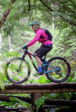
Liv Tempt 4
PREV1 of 2NEXT
Get on the dirt and ride your way to your first singletrack.Tempt is that friend that opens a whole new world to you.
$640.00
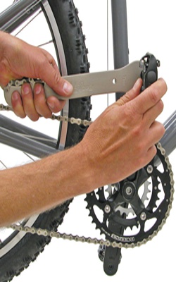
Cycle Path Tire Lever
Sold in sets of two, CyclePath Tire Levers are made of nylon to ensure long life and damage-free operation. The unique design actually ...
List Price: $5.00
Price: $3.99
Team Athens Ohio Cycling Cap
Show you pride with the official Town & Gown Team Athens Cycling Cap including an Essence of Athens Brim. One size fits most.
List Price: $20.00
Price: $19.99
Planet Bike Eco Rack
Perfect rack to hang your panniers on.
:
Price: $29.99
 

Products


Your Cart

Shopping cart  Shopping cart
0 Product(s) in cart
Total $0.00
» Checkout
 

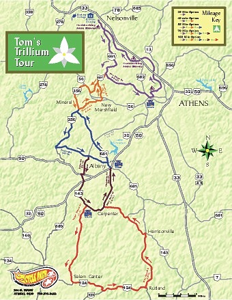
Tom's Trillium Tour

A Great Ride That Starts at Hocking College, Goes South, and Loops back North


Quick Link to Directions and Notes for Each Option
 

There are five separate self guided tours from 26 to 97 miles through the rolling hills of Athens, Vinton and Meigs County. This makes for an excellent ride that you can adjust shorter or extend on the fly.

It is especially scenic in the springtime through the budding dogwood, redbud and wildflowers.


Tom's Trillium Tour
Directions and notes
 
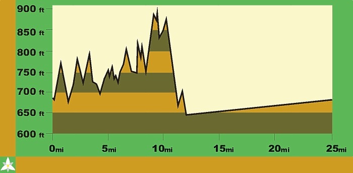
26 Mile Option - Starting at Hocking College (26 profile) (Map)
Direction
.
Where
.
Distance
South
on
Hockhocking Adena Bikeway
for
0.5 miles
Right
on
SR 691 (SOUTH)
for
7 miles
CAUTION: at next turn.....poor visibility
Left
on
CR 22 (Vore Ridge Rd)
for
5.3 miles
Right
on
SR 682 (SOUTH)
for
0.7 miles
Left
on
Union St (at light)
for
0.2 miles
Left
on
Hockhocking Adena Bikeway
for
12.7 miles
to Hocking College and Finish
26 miles total


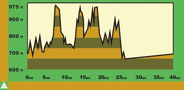
40 Mile Option - Starting at Hocking College (40 profile) (Map)
Direction
.
Where
.
Distance
South
on
Hockhocking Adena Bikeway
for
0.5 miles
Right
on
SR 691 (SOUTH)
for
9.5 miles
Right
on
SR 56 (WEST)
for
1 mile
CAUTION: at next turn.....poor visibility
Left
on
SR 356 (SOUTH)
for
3 miles
Left
on
CR 8 (Mineral Rd)
for
2 miles
Right
on
CR 6 (old 56)
for
0.6 miles
Left
on
Church St.
for
0.1 miles
Left
on.
CR 3B (Steinmayer)
for
0.7 miles
Straight
on
CR 3 (Five Points)
for
2.6 miles
Right
on
SR 691 (NORTH)
for
1.6 miles
Right
on
CR 22 (Vore Ridge Rd)
for
5.3 miles
Right
on
SR 682 (SOUTH)
for
0.7 miles
Left
on
Union St (at light)
for
0.2 miles
Left
on
Hockhocking Adena Bikeway
for
12.7 miles
to Hocking College and Finish
40 miles total

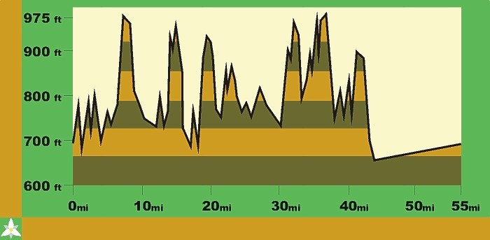
58 Mile Option - Starting at Hocking College (58 profile) (Map)
Direction
.
Where
.
Distance
South
on
Hockhocking Adena Bikeway
for
0.5 miles
Right
on
SR 691 (SOUTH)
for
9.5 miles
Right
on
SR 56 (WEST)
for
1 mile
CAUTION: at next turn.....poor visibility
Left
on
SR 356 (SOUTH)
for
7 miles
Left
on
CR 4 (Worley West)
for
1.5 miles
Becomes
.
CR 14 (Factory Rd)
for
3.5 miles
Right
on
SR 681
for
0.3 miles
Left
on
Lee (STORE AHEAD)
for
0.1 miles
Return
on
Lee
for
0.1 miles
Right
on
SR 681 (NORTH)
for
7 miles
Right
on
SR 356 (NORTH)
for
0.5 miles
Right
on
CR 8 (Mineral Rd)
for
2 miles
Right
on
CR 6 (old 56)
for
0.6 miles
Left
on
Church St.
for
0.1 miles
Left
on
CR 3B (Steinmayer)
for
0.7 miles
Straight
on
CR 3 (Five Points)
for
2.6 miles
Right
on
SR 691 (NORTH)
for
1.6 miles
Right
on
CR 22 (Vore Ridge Rd)
for
5.3 miles
Right
on
SR 682 (SOUTH)
for
0.7 miles
Left
on
Union St (at light)
for
0.2 miles
Left
on
Hockhocking Adena Bikeway
for
12.7 miles
to Hocking College and Finish
58 miles total

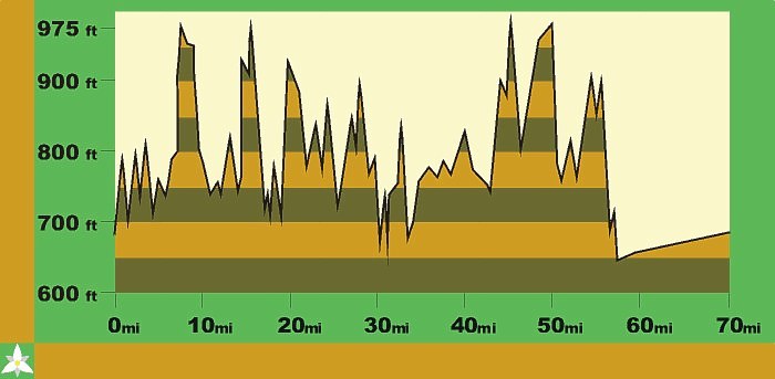
68 Mile Option - Starting at Hocking College (68 profile) (Map)
Direction
.
Where
.
Distance
South
on
Hockhocking Adena Bikeway
for
0.5 miles
Right
on
SR 691 (SOUTH)
for
9.5 miles
Right
on
SR 56 (WEST)
for
1 mile
CAUTION: at next turn.....poor visibility
Left
on
SR 356 (SOUTH)
for
7 miles
Left
on
CR 4 (Worley West)
for
1.5 miles
Becomes
.
CR 14 (Factory Rd)
for
1.5 miles
Right
on
CR 10 (Baker Rd)
for
2 miles
Right
on
US 50
for
0.2 miles
Left
on
SR 143 (SOUTH)
for
6 miles
Left
on
CR 10 (State Farm)
for
2 miles
Becomes
.
CR 13 (Carpenter Rd)
for
2 miles
Left
on
SR 681 (NORTH)
for
0.2 miles
Right
on
SR 681 (NORTH)
for
0.1 miles
Straight
on
Washington
for
0.1 miles
STORE on Right
Left
at
Bank in Albany
for
0.1 miles
Right
on
SR 681 (NORTH)
for
7 miles
Right
on
SR 356 (NORTH)
for
0.5 miles
Right
on
CR 8 (Mineral Rd)
for
2 miles
Right
on
CR 6 (old 56)
for
0.6 miles
Left
on
Church St.
for
0.1 miles
Left
on
CR 3B (Steinmayer)
for
0.7 miles
Straight
on
CR 3 (Five Points)
for
2.6 miles
Right
on
SR 691 (NORTH)
for
1.6 miles
Right
on
CR 22 (Vore Ridge Rd)
for
5.3 miles
Right
on
SR 682 (SOUTH)
for
0.7 miles
Left
on
Union St (at light)
for
0.2 miles
Left
on
Hockhocking Adena Bikeway
for
12.7 miles
to Hocking College and Finish
68 miles total

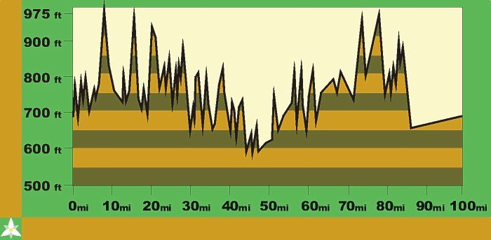
97 Mile Option - Starting at Hocking College (97 profile) (Map)
Direction
.
Where
.
Distance
South
on
Hockhocking Adena Bikeway
for
0.5 miles
Right
on
SR 691 (SOUTH)
for
9.5 miles
Right
on
SR 56 (WEST)
for
1 mile
CAUTION: at next turn.....poor visibility
Left
on
SR 356 (SOUTH)
for
7 miles
Left
on
CR 4 (Worley West)
for
1.5 miles
Becomes
.
CR 14 (Factory Rd)
for
1.5 miles
Right
on
CR 10 (Baker Rd)
for
2 miles
Right
on
US 50
for
0.2 miles
Left
on
SR 143 (SOUTH)
for
4 miles
Right
on
C 1 (Salem School)
for
9 miles
Left
on
SR 124
for
8.5 miles
CAUTION: at next turn.....poor visibility - in Rutland where SR 143 turns right
BEWARE of traffic from right!
Left
on
CR 6 (New Lima)
for
7 miles
Left
on
SR 143 (NORTH)
for
6 miles
Right
on
CR 10 (State Farm)
for
2 miles
Becomes
.
CR 13 (Carpenter Rd)
for
2 miles
Left
on
SR 681 (NORTH)
for
0.2 miles
Right
on
SR 681 (NORTH)
for
0.1 miles
Straight
on
Washington
for
0.1 miles
STORE on Right
Left
at
Bank in Albany
for
0.1 miles
Right
on
SR 681 (NORTH)
for
7 miles
Right
on
SR 356 (NORTH)
for
0.5 miles
Right
on
CR 8 (Mineral Rd)
for
2 miles
Right
on
CR 6 (old 56)
for
0.6 miles
Left
on
Church St.
for
0.1 miles
Left
on
CR 3B (Steinmayer)
for
0.7 miles
Straight
on
CR 3 (Five Points)
for
2.6 miles
Right
on
SR 691 (NORTH)
for
1.6 miles
Right
on
CR 22 (Vore Ridge Rd)
for
5.3 miles
Right
on
SR 682 (SOUTH)
for
0.7 miles
Left
on
Union St (at light)
for
0.2 miles
Left
on
Hockhocking Adena Bikeway
for
12.7 miles
to Hocking College and Finish
97 miles total
Ride on Hocking Parkway to Nelsonville or out and back on the bikeway to add 3 more miles so you can say you did a century. 100 miles total


* The 25 and 40 mile routes are entirely in Athens County
* The 68 miler is only 10 mile longer than the 68 miler, but adds quite a few hills (hills are good for you)
* Stores are few. It is about 25 miles to the the first store on the 40+ options.
 
Emergency
Emergency/Sheriff
Athens County
911 or 593-6633
Vinton County
911 or 596-5242
Meigs County
911 or 992-3371


Athens, Vinton and Meigs County area code (740)


26 Mile Loop - Profile

Maximum Climbing Grade
9 % 
Distance Spent Climbing 13 miles
Lowest Elevation
640 ft
Peak Elevation
895 ft
Total Climbing Elevation
770 ft


40 Mile Loop - Profile

Maximum Climbing Grade
12 % 
Distance Spent Climbing 20 miles
Lowest Elevation
640 ft
Peak Elevation
974 ft
Total Climbing Elevation
1,523 ft


58 Mile Loop - Profile

Maximum Climbing Grade
12 % 
Distance Spent Climbing 30 miles
Lowest Elevation
640 ft
Peak Elevation
974 ft
Total Climbing Elevation
2,394 ft


68 Mile Loop - Profile

Maximum Climbing Grade
12 % 
Distance Spent Climbing 36 miles
Lowest Elevation
626 ft
Peak Elevation
974 ft
Total Climbing Elevation
2,945 ft


97 Mile Loop - Profile

Maximum Climbing Grade
12 % 
Distance Spent Climbing 50 miles
Lowest Elevation
584 ft
Peak Elevation
974 ft
Total Climbing Elevation
4,217 ft


Cycle Path recommends wearing a helmet, obeying all traffic laws and riding within your limits.

Ride responsibly.


Shop Brands We Love